GIS and Risk mapping
In terms of capacity building, integrated risk mapping and modeling taking into account epidemiological environmental and social variables is one of our objectives.
Throughout the activities carried out in ComAcross, target groups’ training needs are identified. We focus on technical skills which can improve civil servants, researchers and field operators' cross sectoral and interdisciplinary perspective and systems thinking ability. Target to conduct field work and data collection in the framework of the three case studies.
Our assumption is that these skills are necessary to conduct health risks assessment and management at the animal, human and environmental interface in the life context of rural communities in Cambodia, Laos and Thailand.
In terms of capacity building, integrated risk mapping and modeling taking into account epidemiological environmental and social variables is one of our objectives.
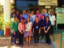
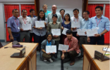
Find below: trainings that have already been held since December 2014 by the ComAcross project and some planned upcoming training for the year 2016.

The first QGIS training has been held in Kasetsart University kamphaeng saen campus from the 30th November – 4th December 2015.
Under the umbrellas of BioZoonoSEA platform”, the NAHIAT, Network on Atypical Human Infections by Animal Trypanosomes, and GREASE network
|
|
|
|
|