In terms of capacity building, integrated risk mapping and modeling taking into account epidemiological environmental and social variables is one of our objectives. A series of training workshops dedicated to ComAcross stakeholders are aiming at developing such skills within a systems thinking approach.
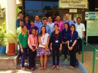
After a first basic GIS course held in December 2015 in Thailand, the second QGIS training has been held at the Pasteur Institute in Cambodia (Phnom Penh) from the 15th to 19th February 2016 with 13 participants from Cambodia. At the end of the training, participants were able to: know the basic concepts, theories, and principles of Geographic Information System, master all basic functions of QGIS for creating maps, and conduct thematic analyzes and simple queries to represent and analyze data from their case studies.
Three (3) additional GIS courses will take place in 2016 and 2017:
- From 9th to 13th May 2016: Advanced spatial analysis, Multi Criteria Evaluation and application to knowledge-based risk mapping (at Kasetsart University, Thailand)
- October/November 2016: Advanced spatial analysis, statistical analysis, risk mapping using QGIS and R freewares (Vientiane, Laos)
- January 2017: web mapping, remote sensing, training workshop valorizing the case studies’ data (to be defined)